
NWR

02
DIGITAL MODELLING
MORE THAN DATA
Orthorectified maps are site-specific, high resolution digital elevation geo-referenced mosaics.
The image is acquired by lasers, highly accurate GPS coordinates, visible light spectrum or near-infrared cameras depending on application and data requirements.
The uses of near-infrared imagery include detailed Vegetation Index (NDVI) maps, which represent direct measures of plant vigour and density. This technology is increasingly applied in viticulture and agriculture.
Another common application is the creation of 3-D surface models that can be generated for sites requiring volumetrics.
The resulting imagery has been geometrically corrected so that it has the spacial integrity of a map. Other products can be produced resulting in vector GIS layers with features such as roads, buildings, hydrology, and other ground features.
 Still_Valley_render_557395 | 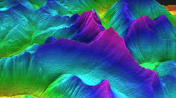 buckridge_asses_57690 |
|---|---|
 vegdensity_ir_45689c |  GPS_4645 |
 GPS_Unit3_dale |  Morris_5658 |
 Annis_topo_geo_387567 |  Banff_wireframe_white_38254 |